(Follow along on the Google map for IMMORTAL OUTLAW. Be sure to play with the various options like terrain and satellite for different views.)
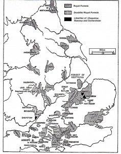
At their grandest, around the year 1200, the Royal Forests covered somewhere between a quarter and a third of England (click on map below to see larger image). These weren’t forests as we understand them now (i.e. thickly wooded land), but were made up of heath and meadow and bog as well as woods — any ground, in other words, that provided habitat for the game and fowl needed to support the royal household. Provisions and sport were the reason for the forests’ existence: William the Conquerer’s love of hunt had led him to create the Forest system almost as soon as he landed in England. His son, William Rufus (who made an appearance in IMMORTAL WARRIOR) was actually killed while hunting in the New Forest, by a bowman who I can only surmise was an ancestor of Dick Cheney.
 The Shire Wood (Sherwood) was not the biggest of the Royal Forests, but it is definitely the most famous today because of it’s association with the legend of Robin Hood and his Merry Men. Like all the royal forests it contained areas of open woodlands and mixed vegetation, but it was especially well-known for its dense canopies of ancient oaks, so thick in some areas that they made the roads nearly impassable and threatened to sweep riders off their horses. These wild woods, which extended into southern Yorkshire and eastern Derbyshire, made a perfect place for outlaws to accost travelers and then disappear out of reach of the law.
It was just such a group of bandits that Marian and Robin encountered as they travelled from Loxley to their first goal of the Lady Well at Headon. They would have just entered the edge of the forest along what is now more or less the M1 Motorway when attacked, but roads in this northwestern border area were especially dangerous because the maze of caverns at Creswell Crags were close enough to provide even more cover for miscreants (Steinarr hid in the Crags himself in earlier years).
Sadly, only 165 square miles of Sherwood Forest remain today, less than 0.5% of its original size, and it’s populated by a mere 1000 or so of the millions of oaks that once blanketed the land. Fortunately, one of those surviving oaks is the Major Oak, the immense tree in which Robin Hood once hid from the Sheriff, and my model-very rough model-for the elf house (more on that later in our journey).
 Once he’d rescued his “pilgrims,” Steinarr escorted them to the nearest village of any size that was properly along their route—Maltby, So. Yorkshire—even though he had to veer well north to do so. In the village, which dates back to ancient times, Marian might have noted the remains of several Roman roads that ran through the village, which was surrounded by rich farmlands. The current church building dates back only to 1859, but the square-topped tower you can see in the picture dates back to Norman times and would have been watching over Steinarr and Marian’s first kiss.
Next up: Headon and the Lady Well
![]()


Permalink
Hi Lisa,
I enjoyed reading about Sherwood Forest. Your remark about a Dick Cheney relative cracked me up.
Take care, Maggie
Permalink
Permalink
https://shorturl.fm/88REK